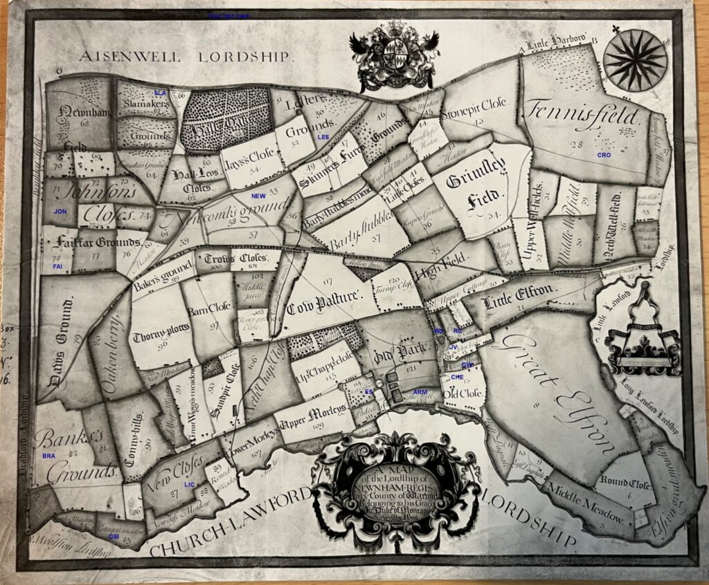
A Tithe map for the village, along with details of farmers and villagers, dated around 1720, has been kept in the records of Lord John Scott and published in various locations. A copy of the Lord John Scott maps are held in the Warwick Records Centre – the originals are in the Montage Family Archive.

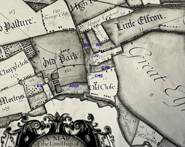
Various annotations have been added in blue to the map above to help locate the residents of the area at that time. A more detailed view of Newnham Village is at the bottom of this page. The following chart lists those named on the tithe records, with an idea of the area they were farming and a code link to the above map – with those residing in the Newnham Village area also shown on the detailed map at the bottom of the page.
| Name | Residence | Land Location | Land Area | Code |
| Henry Armston | Newnham Mill | 12 acres | ARM | |
| William Bradford | Newnham Grounds Area | 54 acres | BRA | |
| Richard Cattel | Newnham Village Area (see code) | Smallholding | 40 acres | RC |
| William Checkley | Cottage in grounds of Manor Farm | Tithes 9, 10 and 13 alongside Avon | 16 Acres | CHE |
| William Croft | Fennis Field | Tithes 25-30, 33, 34, 42-44 | 233 acres | CRO |
| Widow Fairfax | Area on Fosse near Abbey Hall Farm | 25 acres | FAI | |
| William Gibbards | Newnham Grounds Area | 57 acres | GIB | |
| Richard Green | Assumed to be in Newnham Village | |||
| George Johnston | Abbey Hall Farm Area | 31 acres | JON | |
| William Lester | Area on Cathiron Road | 32 acres | LES | |
| Joseph Licorish | Newnham Grounds Area | 32 acres | LIC | |
| Thomas Newcombe | Central area called Newcomb’s Grounds | 105 acres | NEW | |
| Thomas Slamaker | Area between Brinklow and Hall Oaks | 74 acres | SLA | |
| Edward Smith | Newnham Hall | Tithes 89, 92,93, 95-105, 113-121 | 248 acres | ES |
| William Sutton | Newnham Village Area (see code) | Tithes 20,23,24, 31,32, 54, 62,63,66 | 69 acres | WS |
| John Veer | Newnham Village Area (see code) | Tithes 1-8, 19,21 | 198 acres | JV |
| George Worth | Newnham Village Area (see code) | Tithes 35-41, 107-9 | 124 acres | GW |
Also listed as having small interests in this area at that time were Clement George and Ben Collis who appeared to have larger holdings in Church Lawford. There is also a William Croft based in the Church Lawford area, with 99 acres roughly in the modern Rookery Hall area, but whether this is the same person as in King’s Newnham isn’t too clear given the distances involved. The Croft / Crofts family had many interests in the local area over several centuries.
The zoomed in version of the map, shown below, helps to locate the residents of Newnham Village in 1720.

For a full list of the tithe allocations for both villages see here.
