This page attempts to highlight those village locations that will no longer appear on a current map, including those names that have changed over the years. A map, from the 1960s, has been annotated with a key for a number of locations from the past 150 years or so. This was the first detailed map to adopt the street names as they are still known in the 21st Century. It is focussed in the centre of Church Lawford Village, as this is where most of the change has occurred, and is followed by the key with links to the various places in the archive where more details can be found.
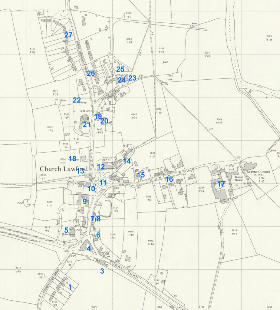
| Key | Item |
| 1 | Pleasant View (1950s) / Middle Lane (local name to 1953) |
| 2 | Fog Cottages (Late 19th to 20th Century) (off map – at Skew Bridge) |
| 3 | Village Shop (1874-1957) Sheff’s Cafe (1958-65) |
| 4 | Village Wheelwright / Triangle Garage (19th & 20th Centuries) |
| 5 | First Village School / Maypole (1849 – 1964) |
| 6 | Village Smithy (1920s-70s) |
| 7 | Village Bakehouse (Late 19th to mid 20th Century) |
| 8 | Village Pump (to mid 20th Century) |
| 9 | Village Farm (19th and early 20th Century) |
| 10 | Fir Tree Farm (19th and early 20th Century) |
| 11 | Village Stocks (19th Century to early 1900s) |
| 12 | White Lion Inn (1840-1992) |
| 13 | Last Village School (1964-1996) |
| 14 | Little End (local name to 1953) |
| 15 | Village Butcher (to 1949) |
| 16 | Village Pump (to mid 20th Century) |
| 17 | Manor House Farm Church Lawford (several centuries) |
| 18 | Reading Room (1912-2007) |
| 19 | Village Post Office (interwar period) |
| 20 | Kinver Farm (varied periods) |
| 21 | Vicarage (many centuries to 1979) |
| 22 | Glebe Field (to late 20th Century) |
| 23 | Village Smithy (19th Century to 1920s) |
| 24 | Veterinary Surgery (1950s to 1980s) |
| 25 | Eastlands Farm (19th Century to 1950) |
| 26 | Village Shop / Post Office (1960s to 2000) |
| 27 | Airey Houses (1950s to 1996) |
| 28 | Church Lawford Nursery / Garden Centre (1960s to 2011) (off map at top) |
Changes to other Village Farms, such as the loss of Ling Hall Farm are introduced via the Village Farms page here. Note that the modern postcode CV23 9HB is regarded as a Church Lawford postcode, but also embraces land and properties in the Wolston Parish – hence Vicarage Farm near Bretford has a Church Lawford address, but is not part of Church Lawford parish. In that area can be found Bunkers Hill Lane, which historically marked the boundary of those two parishes where they meet the Coventry Road – but then loops aways towards the Fosse Way, joining it just before the railway bridge.
Notable places in King’s Newnham that are no longer located on current maps are King’s Newnham Mill, King’s Newnham Baths and King’s Newnham Lime Workings.
A discussion on the old cottage numbers in both villages, along with perceived locations can be found here. That list also considers some King’s Newnham Locations such as the cottages at Newnham Grounds and Butlin’s Barn.
The above map is reproduced with the permission of the National Library of Scotland. This map and more can be found via this link. There are different ways of navigating the maps there – the “Marker Pin” option is ideal for finding maps that cover a particular area, and the “Side By Side” viewer is excellent for comparing an old map with a current day view. An index to village maps through the ages can be found here.